

While location-based marketing is widely practiced, understanding and effectively using location-based audiences remains a challenge for small to mid-sized agencies and brands.
Digital marketers are faced with a myriad of tools, jargon, and technology that makes what should be a straightforward process more complex than necessary.
On February 12, I moderated a sponsored Search Engine Journal webinar presented Dan Dillon, VP of Marketing at Reveal Mobile.
Dillon shares tips on how marketers can use location data to acquire new customers and steal market share from competitors.
Here’s a recap of the webinar presentation.
Who Cares About Location-Based Marketing?
If you think for a minute about the wide range of marketing strategies, tactics, and technologies, it gets pretty dizzying pretty fast.
It’s a great time to be a digital marketer, and it’s also one of the hardest times to be a digital marketer.
The pressure is on to deliver pipeline and revenue, so there’s also pressure to choose the best methods for driving sales.
The data shows just how effective location-based marketing is at doing that.
- Mobile Marketer tells us that nearly 90% of us use location data in campaigns.
- eMarketer research shows that we’re increasing our investment in location-based advertising 40% year over year. This makes it one of the fastest-growing marketing tactics for consumer and retail segments.
Location data and location-based advertising have definitely come into their own. Marketers know a good thing when we see one, and location data is the gift that keeps on giving.
Key Terms in Location-Based Marketing
Before diving into the topic, let’s cover some key terms and provide some useful context into location-based advertising.
Geofencing
Geofencing is one of the most searched keywords by digital marketers looking to do location-based marketing.
It involves creating a virtual barrier around a physical location. This can either be a radius around a large location or a polygon around a specific building or store footprint.
Here’s an example of a polygon around a Publix grocery store.
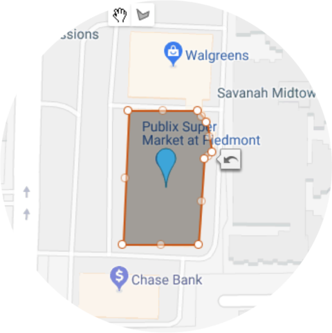
You can see how this level of accuracy enables you to run a very different kind of geotargeting campaign from the targeting you can do on Google Ads.
Geofencing also refers to advertising when someone enters that virtual barrier. A targeted audience member may receive an alert, a push notification, or an ad within a mobile app-based upon their location.
Geofencing is actually the most prevalent tactic in location-based advertising, accounting for nearly 50% of all location-based marketing.
Geotargeting
Geotargeting refers to delivering ads to people who have visited a specific location. This might involve serving ads for organic groceries to people who have recently been to Whole Foods, Trader Joes and Sprouts.
Geoconquesting
Geoconquesting refers to advertising to people who were previously in a competitor’s location with the intention of winning them away from that competitor.
An example of this might involve advertising Chick-Fil-A’s new sandwich to people who recently visited KFC, Church’s, Popeyes, and Wendy’s.
This is by far one of the most valuable and underutilized methods of location-based marketing, something you should try out with your next campaign.
Best Fits for Location-Based Marketing
There are typically three main segments of businesses that are the best fit for location-based marketing.
1. Have Multiple Retail Locations
Such as:
- Retailers & Franchises
- Auto Dealers
- Food & Dining
2. Run Seasonal or Special Events
Including:
- Events & Concerts
- Travel & Hospitality
- Major Sports
3. Want Audiences That Visit Specific Retail Locations
Such as:
- Ecommerce – Find shoppers that visit their retail competitors.
- CPG Brands – Find shoppers that visit stores where their products are carried.
How Location-Based Marketing Works
Let’s take a quick look at how location-based marketing works, starting with how location data is best sourced and how it flows to you as a marketer.
The vast majority of location-based marketing is powered by opted-in GPS data.
When a person opts-in to share their location with a mobile app, the latitude/longitude data gathered from that app is what powers your ability to target them based on their location.
GPS data is the most accurate and has the most meaningful scale.
So the process looks like this:
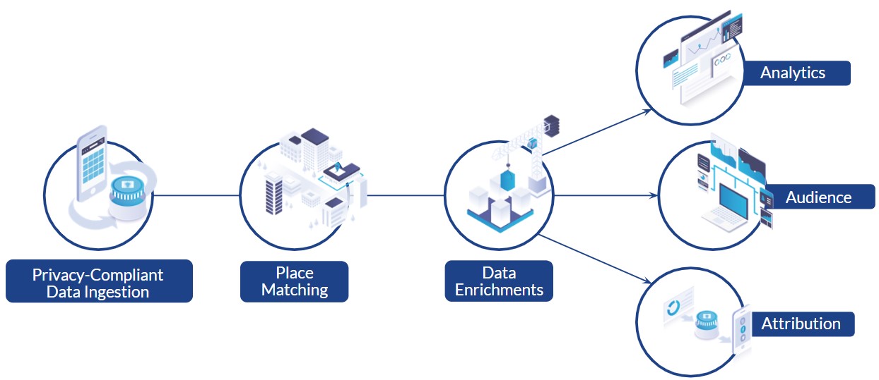
GPS data is ingested, aggregated and anonymized to prevent the identification of individuals and make sure the data is clean. This ensures the data is privacy compliant.
Next, the data is matched to places – a retail business, a venue, an auto dealership, what have you.
This is one of the most critical steps in the process, as it requires up-to-date business information – keeping track of which stores open and close, categorizing them correctly – as well as keeping up-to-date footprints of buildings in order to be able to know what devices show up there.
The next step, which is optional, is data enrichment. This might involve appending demographic or behavioral insights to the location data. This is done with a customer data platform or some other piece of the martech stack.
Then we get to the three core elements of location-based marketing: analytics, audiences, and attribution.
The analytics piece enables you to understand your target audiences based on where they shop, how often they shop at those places, how far they travel to get there, etc.
This lets you get smarter about your potential ad spend. Once you understand these things, you want to have a method for building location-based audiences to market to.
This is most easily done via a user interface that you can log into directly, enabling you to self-serve and get precisely the audiences you want.
You’ll then want to be able to push those audiences to a DSP or a social ad platform so you can serve ads and drive activations.
Lastly, you’ll want to be able to understand how your ads performed. That’s the attribution piece, showing you who among your audience went to the retailer you’re advertising or visiting the location you want your audience to visit.
It could be an amusement park, a concert, a coffee shop, or anything in between.
Location-Based Marketing & Privacy
We can’t talk about location-based marketing without talking about privacy. All of the location data you use must be privacy compliant.
The hallmarks of privacy, when you go looking for a location-based marketing vendor, are:
- Honoring all OS opt-outs
- De-identified, aggregated data sets – which means specific individuals cannot be singled out from an audience
- CCPA compliant
You’ll also want to ask about the vendor’s involvement in privacy advocacy and working groups:
- IAB Transparency & Consent Framework Vendor Registry
- IAB Public Policy Committee
- Mobile Marketing Association Privacy Committee
- Future of Privacy Forum members
- Privacy Shield Framework
Geotargeting & Geoconquesting Case Studies
Reach & Win Over Moe’s Diners
Moe’s wanted to geotarget and geoconquest to reach existing Moe’s diners and win over new customers.
Their goal was to:
- Drive downloads of Moe’s app and coupon redemption.
- Increase foot traffic to restaurants.
- Win over customers going to competitive locations.
To do this, they decided to:
- Advertise across social media.
- Use custom audiences on Facebook.
To find their audience, they geofenced:
- Their own visitors to Moe’s.
- Direct competitors, such as:
- Qdoba
- Chipotle
- Indirect competitors.
- Mexican Restaurants in Raleigh, North Carolina area.
Overall, they were looking at an audience of about 20,000 individuals. Facebook matched 85% of this audience (17,000).
And so they were able to market to 17,000 existing and potential diners.
As a result of that campaign, what they saw was a 67% increase in app download conversions, as well as an increase in customer loyalty.
Using Custom Audiences to Reach Elvis Fans
Sony Music, which has a massive catalog of Elvis Presley music, released a posthumous album titled “Where No One Stands Alone” which was composed of 14 original songs.
Sony wanted to find Elvis fans to promote it so decided to run a campaign with the goal of driving awareness, sales, and streams of the new album.
In addition to messaging the new album through their email newsletter, they also built a location-based audience, visitors to Graceland, over an extended period.
The thinking was that if you’d visited Graceland, then you’re likely a huge Elvis fan.
The audience size of Graceland visitors was about 13,000.
This location-based audience was imported to Facebook as a custom audience, and Facebook matched 88% of this audience to their user base.
Ads were served to this audience on Facebook’s website and mobile app.
As a result, the ad reached 55% of the audience in one week.
Their CPM cost was 35% higher due to the highly targeted audience, however, it was 20% lower than their email list targeting.
Overall, they gained 527 clicks with a 1.7% CTR, plus the ads were shared 30 times.
Which Location-Based Marketing Option Should You Choose?
Before you decide which path is appropriate for you, decide on what you’re trying to accomplish.
What to choose should line up with your goals– whether those are brand goals, business goals, client goals, campaign goals, etc.
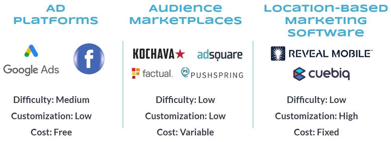
Ad Platforms
We all use the major platforms for advertising. The nice thing about Google Ads and Facebook is that they’re free and everybody uses them.
But when it comes to using them, getting support and managing campaigns can be cumbersome.
When it comes to customization, it’s not possible to get highly targeted audiences. You can’t get the audiences that described in the above case studies.
You can geotarget a city or a state but you just can’t get down to a store or a chain store level with Google Ads or Facebook.
In the end, they really enable more of a spray-and-pray approach to location-based marketing.
Audience Marketplaces
These are platforms that enable you to get a geo-targeted audience based on general characteristics of an audience. For instance:
- Coffee drinkers.
- Golfers.
- Moviegoers.
- Etc.
These are the demographic consistencies among an audience, but you really can’t get more specific than that. Not a lot of customization occurs with these audience marketplaces.
They’re very easy to access. You can sign on and pull audiences out quickly and your cost is going to be variable depending on what audiences you choose.
You’re also generally going to be required to spend a minimum on media. Often, to get to those audiences, you have to commit a specific number per month on media spend.
Thus, you’re pretty locked in if you have this option you’re pretty locked into using that platform and your cost is going to be variable and harder to predict.
Location-Based Marketing Software
Location-based marketing software providers are where you find a nice intersection of easy-to-use and also a high level of customization.
This option is going to allow you to geo-target down to the store level. You can also get a look-back period for whatever time you’d like.
You can also get creative here and find very specific audiences.
For example, an auto dealership might want to geo-target their audience made up of people who visited their lots and dealerships only in the last seven days – knowing that car buyers who are ready to buy show up on a lot with a check in hand.
There are very specific use cases for this kind of software that are just not able to be accommodated in other platforms.
You’re also going to have a predictable cost for this option so you can budget easily.
If you’re an agency, you can event pass this cost on to clients in the form of retainer or monthly fees or in marking up media.
Questions to Ask Yourself to Ensure Optimal Campaign Performance
Audiences
- Are you verifying that audiences are opted-in and privacy compliant?
- What to look for:
- CCPA compliance
- Data source type – GPS
- Vendor honors location sharing opt-outs
- No personally identifiable information (PII)
- What to look for:
- Is the device data time-stamped?
- What to look for:
- Vendor assigns and provides time stamps for all events captured per device.
- Vendor provides time stamps as part of data feed.
- Advertiser can build audiences for custom time periods and look-back windows.
- What to look for:
- What is the scale of your device data?
- What to look for:
- Number of Daily Average Users (DAUs) – this number serves as a baseline for the number of mobile users you’ll be able to build an audience from
- Events per Device – this number serves as a baseline for the depth of data on each device. The more events per device, the more likely you’ll see each place that device visits. Better accuracy and completeness of location data enables advertisers to target more effectively and efficiently.
- What to look for:
- How up-to-date are your audiences and how often are they refreshed?
- What to look for:
- For audience building and attribution purposes, audience data should be thoroughly refreshed every 24 hours.
- What to look for:
Places
- How comprehensive is your place information?
- What to look for:
- Place of interest (POI) databases vary in size. An average U.S. POI database includes less than 10 million places of interest. It’s important to understand what countries are covered in the vendor’s POI. It’s also important to ensure the vendor’s POI database is organized in a way that makes it easy to use.
- Vendor allows advertisers to quickly and easily create custom places in the POI database. If you’re targeting a well known national chain, then there’s no issue. But what if you need to add a local set of locations that aren’t in the POI database?
- Vendor allows advertisers to bulk upload custom places to a point-of-interest database. If you’re targeting 1,500 retail locations, you don’t want to have to manually enter each one.
- Vendor allows advertisers to use their own place data. If you already have the place details for the locations you want location data for, you should be able to use your own set of POI data.
- What to look for:
- How precise is your place information?
- What to look for:
- Vendor’s POI database discerns between large structures, such as shopping malls and airports, and individual retail locations within those structures. For example, the vendor allows you to target Mall of America or the Nordstrom store within the Mall of America. Similarly, the vendor allows you to target O’Hare International Airport or just focus on the Starbucks locations inside O’Hare.
- The location data the vendor works with should be accurate down the foot. This is sometimes expressed in decimal degrees. Vendor’s location data should process events accurate to 6 decimal degrees. This ensures that devices seen at a specific location were actually at the location, enabling you to get the highest quality audiences and most reliable attribution.
- What to look for:
- How do you verify your place information and compensate for bad addresses?
- What to look for:
- Vendor regularly updates and matches POI database to latitude/longitude coordinates.
- What to look for:
- How do you filter out locations that are not appropriate for my campaign’s needs?
- What to look for:
- Vendor’s solution enables advertisers to build audiences based on individual locations, eliminating all others if desired.
- What to look for:
Q&A
Here are just some of the attendee questions answered by Dan Dillon.
Q: As an agency, how would you classify location-based services to potential clients, and what would be a relevant approach for a pricing strategy?
Dan Dillon (DD): We work with a lot of digital agencies. This is one of the best questions they can ask.
We see agencies positioning location-based marketing to clients as a way to improve targeting and getter a better ROI on their ad spend.
Our VISIT Local product includes pre-built foot traffic analytics reports that you can bring into pitch meetings to help you win more business. These reports are an ideal way to bring insights to your prospects and clients that they can’t get anywhere else.
As for pricing, the most progressive agencies are actually making money from using VISIT Local. They bake the cost of the product into their fee and spread it out across their clients.
They also increase their media mark-up, knowing that the ads are more highly targeted and may result in a higher ROI for clients.
We’ve priced VISIT Local so smaller agencies can take advantage of location-based marketing strategies and more effectively compete with larger agencies.
Q: Can you search up and target a specific business location by typing in “taco bell” or “subway” on Facebook?
DD: No. You can target audiences on Facebook based on pages people have liked, but that doesn’t mean they have visited a Taco Bell or a Subway restaurant.
This is what makes location data so valuable. It allows you to target audiences who have actually been to brick-and-mortar locations you care about and who therefore are most likely to convert on your call to action.
Q: I’m having a hard time convincing team members that we need to consider location data in our approach. I need help convincing them that location-based marketing is valuable.
DD: You can do this a couple of ways. Industry data is very helpful in showing how valuable location-based marketing is.
Mobile Marketer says that nearly 90% of marketers use location data in campaigns. Merkle says that more than 60% of marketers use location data to drive personalization. eMarketer tells us that investment in location-based ads is growing by 40%.
You can also share case studies of successful campaigns that leverage location data. There’s a great selection to choose from at Reveal Mobile.
Q: If the GPS of users’ phones are not on, how do you capture the location of these users?
DD: We don’t. If a mobile device isn’t sharing its location, then that device will not show up in any location-based audiences. This ensures consumer privacy.
Reveal Mobile honors all opt-out requests, which is just one of the ways we comply with CCPA (the California Consumer Privacy Act) and ensure customers get the highest quality audiences.
[Video Recap] How to Outsmart Your Competitors & Win Market Share Using Location Data
Watch the video recap of the webinar presentation and Q&A session.
Or check out the SlideShare below.
Join Us For Our Next Webinar!
The AEO Playbook: How to Get Cited & Stay Visible
Join Lindsay Boyajian Hagan, VP of Marketing, and Pat Reinhart, VP of Services & Thought Leadership at Conductor, walk through a full AEO Playbook for assessing your maturity, strengthening the four pillars of AI visibility, and operationalizing AEO across enterprise teams.
Image Credits
All screenshots taken by author, February 2020
